Why Drones are the New Brushes of Photography?

Perspective has always been an important element in photography. Every era has brought new technologies that have influenced how we record and see the world, from the development of the camera to the emergence of digital editing. Drones are changing this art form nowadays. They are more than just propeller-powered machines; they are the new paintbrush of photography as they can capture views from previously unthinkable perspectives.

The Artistic Shift with Drone Photography

While conventional cameras enable us to record situations at eye level, drone photography for landscapes in Los Angeles truly pushes the boundaries of creativity. Imagine flying across bright deserts, soaring above metropolitan skylines, or floating above rocky coasts. Photographers can use drones to produce expansive compositions that emphasize the interplay of light, shadow, and land. Many people view drones as the most advanced artistic tool of our time because of their capacity to expose patterns, textures, and scales.

Drone Photography for Landscapes in Los Angeles

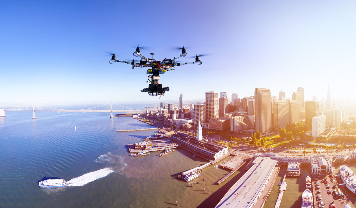
Drone photography is particularly popular in Los Angeles. The city offers a variety of vistas that demand to be seen from above, from the glittering waters of the Pacific Ocean to the striking backdrop of the San Gabriel Mountains. Creatives who wish to document the city’s natural beauty and urban sprawl are increasingly using drone photography for landscapes in Los Angeles. Drones allow photographers to explore new subjects, such as the dazzling downtown cityscape at sunset or the sunrise over Malibu.

Why Drone Services Companies in Los Angeles Are in Demand?

Drone services companies in Los Angeles are flourishing since not everyone owns or is proficient in using a drone. These experts provide more than just aerial gear; they also contribute knowledge of composition, licensing, editing, and safety. Hiring a Los Angeles drone photography service guarantees both artistic and technical accuracy for filmmakers, real estate brokers, tourism boards, and even couples planning unique wedding photography.

The Future of Photography is in the Sky

Drones are getting smaller, cheaper, and more capable of producing cinematic-caliber photography as technology develops. Because of its accessibility, more artists may try their hand at aerial photography, which results in more creative narratives and more vivid visuals. Drones are revolutionizing modern photography by providing us with new methods to interpret emotions and landscapes, just like paintbrushes did centuries ago.

Drone photography is ultimately extending the possibilities of traditional photography rather than displacing it. Drones are more than simply devices for photographers in Los Angeles and elsewhere. They are creative tools, like paintbrush in the sky, that paint the world in ways we haven’t fully explored yet.

Frequently Asked Questions

Why is drone photography for landscapes in Los Angeles becoming so popular?
Drone photography for landscapes in Los Angeles is popular because it showcases the city’s unique mix of beaches, mountains, and skylines from angles impossible with traditional cameras, creating captivating and cinematic visuals.

What makes drone services companies in Los Angeles valuable for photography projects?
Drone services companies in Los Angeles provide expert piloting, high-quality equipment, and knowledge of regulations, ensuring safe, legal, and visually stunning photography that clients may not achieve with personal drones.

Can a Los Angeles drone photography service be useful for businesses?
Yes, businesses such as real estate firms, tourism boards, and film studios benefit from Los Angeles drone photography service because it offers dynamic visuals that attract audiences, highlight properties, and elevate branding strategies.

Do I need a license to fly a drone for photography in Los Angeles?
Small drones may not require licensing if used for personal purposes, but commercial drone photography in Los Angeles demands FAA certification and adherence to local airspace regulations. This is why professional services are often recommended.

How do drones compare to traditional photography for landscapes?
While traditional photography captures eye-level details, drones provide breathtaking aerial perspectives. They highlight patterns, scale, and composition in landscapes, offering photographers and viewers a more immersive and artistic experience.


How Drone Photography Transforms Landscapes?

Imagine enjoying a stunning sunset while standing atop a hill. Now imagine the same scene from 400 feet above the ground, where the sun’s rays are captured as they reflect off of roofs, valleys, and ocean waves. That is now a cinematic experience rather than just an image. That is the potential of drone photography for landscapes in Los Angeles.

Traditional cameras are limited in a city where the skyline meets the shoreline and deserts kiss the mountains. However, drones? As drones take to the skies, so do our viewpoints.

The Sky Isn’t the Limit, It’s the Starting Point

There is plenty of beauty in Los Angeles. Every location, from the coastal cliffs of Malibu to the meandering paths of Griffith Park, has a story to tell. Drone services companies in Los Angeles are becoming the contemporary storytellers, substituting expansive overhead images that capture the entire majesty of these locations for words.

A still landscape can become a dynamic visual story through drone photography. Consider this: how many times have you wished you could get a picture of the entire coastline as you were driving along PCH? Drones make that not just feasible, but also artistic.

A New Era of Cinematic Landscapes

Here, at Los Angeles Drone Cinematography, technology and narrative combine. Drones provide us with experiences rather than simply pictures because of their 4K resolution, hyper-stable gimbals, and creative flight patterns.

They are also quite adaptable. Do you want to take a sunrise slow pan over the San Gabriel Mountains? Or perhaps a spectacular fly-through of the desert of Joshua Tree? Drone photography improves our perception of our environment, both physically and symbolically, whether it is used for real estate, tourism, cinema, or personal art.

Why Landscapes Look Better from the Sky

  • Scale and Context: Aerial shots help you see how a landscape fits into the larger geography.
  • Symmetry and Patterns: Fields, streets, and coastlines often reveal beautiful, natural symmetry from above.
  • Movement and Light: Shadows and light dance differently from the sky, creating moodier and more dynamic visuals.
  • Access to the Inaccessible: Remote hills, cliffs, or fragile ecosystems can be captured without disturbance.

And let’s face it, who receives more attention when browsing Instagram? A beach viewed from the ground, or a dramatic flyover of breaking waves in the middle of the day?

Ready to Transform Your View?

Drone photography for landscapes in Los Angeles is the way to go if you want to capture more than just the surface of a place; you want to capture its soul. Moreover, there are plenty of professionals available at premier drone service companies in Los Angeles who are ready to realize your vision, frame by breathtaking frame.

Frequently Asked Questions

Is drone photography legal in Los Angeles?

Yes, but operators must follow FAA regulations and, in some areas, obtain special filming permits.

Can drones fly in national parks like Griffith or Runyon Canyon?

Most national parks restrict drone use, but some companies work with city officials to get special access.

What’s the best time of day for drone photography?

Golden hour (just after sunrise or before sunset) offers the best natural lighting.

Are drone shots suitable for commercial projects?

Absolutely. Many Los Angeles drone cinematography professionals specialize in commercial landscapes for real estate, tourism, and media.


How Drone Photography is Transforming Landscape Planning & Development

A technical revolution, Drone photography for landscapes in Los Angeles is fundamentally transforming the way developers, architects, urban planners, and environmental researchers plan and carry out landscape projects. This innovative method gives professionals access to rich, comprehensive visual data that was previously unattainable or unaffordable by fusing cutting-edge imaging technology with previously unheard-of aerial perspectives. Drone photography has become an essential tool in contemporary landscape planning and development plans because it provides high-resolution, real-time footage from different viewpoints.


Comprehensive Site Analysis and Mapping

Drone for aerial photography in Los Angeles allows for unprecedented levels of accuracy in topographical mapping and site evaluation. These cutting-edge aerial systems take extraordinarily detailed pictures that highlight complex terrain changes, environmental characteristics, and landscape aspects that are concealed from view from the ground. These days, planners can create incredibly precise 3D landscape models, assess slope gradients, spot possible construction obstacles, and comprehend intricate ecological relationships with amazing efficiency and clarity.


Environmental Impact Assessment

Drone photography provides remarkable insights into the complex environmental monitoring needed for modern landscape development. Researchers can monitor wildlife habitats, analyze vegetation changes, and evaluate any ecological disturbances by taking high-resolution images at various times and seasons. Drone surveys’ non-invasiveness reduces environmental impact while providing detailed information on vegetation density, land usage, and possible conservation sites.


Urban Planning and Infrastructure Development

Urban planning has been transformed by the best aerial photography services in Los Angeles, which provide dynamic, real-time visual data. With previously unheard-of accuracy, city planners may now evaluate the demand for infrastructure, examine urban sprawl, and graphically represent prospective development projects. Drone photography makes it possible to measure land parcels accurately, spot any zoning issues, and produce intricate architectural representations that blend in perfectly with the natural terrain.


Cost-Effective and Time-Efficient Surveying

Drone photography significantly lowers the cost and time commitments associated with traditional landscape surveying techniques. Weeks of ground-based surveying can be replaced with a single drone flight that can gather vast amounts of landscape data in a matter of hours. For landscape development projects, high-resolution photography offers immediate, actionable insights that facilitate quicker decision-making and more effective resource allocation.


Advanced Visualization and Presentation Tools

The way landscape projects are conceived and presented is revolutionized by drone photography. Now, developers and architects can produce realistic, immersive visualizations that provide stakeholders with a thorough understanding of proposed developments. By offering precise, in-depth illustrations of intricate landscape modifications, these cutting-edge visual aids promote improved project approvals, better communication, and more informed decision-making.


Bottom Line

Landscape drone photography in Los Angeles has become a game-changing tool that offers previously unavailable insights into landscape development and planning. It gives experts a potent tool for developing more informed, efficient, and sustainable urban and environmental solutions by fusing cutting-edge image technology with extensive data collecting.


FAQs

In comparison to conventional surveying techniques, how accurate are drone surveys?

By delivering more thorough and precise landscape data, drone surveys often surpass traditional approaches and can attain centimeter-level precision.


Is it allowed to use drones for photography in cities like Los Angeles?

Professional drone services are required to adhere to stringent rules for urban aerial photography, secure the required permissions, and comply with FAA regulations.


Which kinds of terrain can drone technology survey successfully?

Drones can examine a variety of landscapes, such as complicated ecological zones, coastal regions, hilly terrain, metropolitan areas, and agricultural grounds.


What are the advantages of drone photography for environmental researchers?

Comprehensive, non-invasive landscape data is obtained by researchers, facilitating in-depth ecological monitoring, habitat evaluation, and conservation planning.